UbiquiToRe
Ubiquistic Electrical Resistivity Tomography
Scientific responsibility :
- Emmanuel Léger
- Damien Jougnot
- Nicolas Delpierre
- Emmanuèle Gautier
- Christian Mazet
Methodological axes :
Thematic fields :
Disciplinary sectors :
Funding :
- DIM PAMIR
- Département des Sciences de la Terre
Project ID : IDF-DIM-PAMIR-2025-1-002
Summary :
The non-destructive characterization of the near surface allows the quantification of past and current processes in many fields, including geology, hydrology/hydrogeology, geomorphology and archaeology. Geophysical methods make it possible to non-destructively characterize the subsurface through proxies such as electrical conductivity, which is sensitive to geological material, its water content, and the mineralization of the water. The UbiquiToRE project aims to purchase a field resistivity meter to image the subsurface through electrical resistivity tomography profiles in numerous contexts associated with a variety of research topics: imaging of permafrost-active layer, identification of sulphide-rich zones, imaging of faults for gas seepage, characterization of water content available for trees, imaging of alluvial deposits in high latitude contexts. The UbiquiToRE project, through the numerous applications it proposes, aims to create synergies with as many research projects as possible in order to democratize the use of geophysical methods. Beyond the research aspect, the UbiquiToRE project has a strong educational component, as around one hundred students spread over 6-7 teaching units from Bachelor’s to Master’s level are directly concerned with the success of this project.
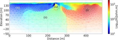
Legend: Electrical resistivity profile illustrating the resolution of the requested device with (i) granite, (ii) saltwater-filled granitic arena, (iii) alternating marl and (iv) gas pocket. Adapted from Léger et al.

